Search This Blog

Monday, December 24, 2012

Hinton Park

A trip to the Louis Armstrong House Museum in Corona, Queens gave this explorer the chance to visit not only Park of the Americas (formerly Linden Park) and National Plaza (formerly Corona Plaza) but Hinton Park as well, a big rectangle just across the Grand Central Parkway from Citi Field, the fancy new home of the New York Mets. Nearby you'll find the Louis Armstrong School and the Louis Armstrong Playground.

No one was playing outdoor chess on this December day, but no matter the weather the compass never tires of pointing in every direction.

Most of the park's acreage is devoted to grassy baseball fields…

…which, you'd assume, would be entirely abandoned in the winter, but you'd be wrong.

Little parks with little character bordering on flavorless highways – that's a kind of identity, I suppose. Reverend George Warren Hinton park is named for a longtime pastor of the Corona Congregational Church, who died in 1969 – the same year the Mets won their first World Series, and long before the building of Citi Field inspired the team to…well, to continue to not be very good. Sigh.

Maybe one day the guys in the photo above can do something about that.

A final note: While it's true that Hinton Park is unremarkable, even lacking anything in the way of a surrounding neighborhood to lend it character, it's also true that walking towards it along 37th Avenue over slightly hilly terrain, passing streets jutting off in irregular directions, I could detect past ages when this land was entirely rural. Imaginative overreach? I don't think so. Try it and see if you agree.

Sunday, December 23, 2012

Park of the Americas and Corona Plaza/National Plaza

Park names are a jumble in the bustling part of Queens known as Corona, a neighborhood I admit I'd previously known only from the line in Paul Simon's song "Me and Julio Down by the Schoolyard." ("Goodbye Rosie, queen of Corona.")

Aiming for a park that's called Linden Park on all the maps, we disembarked from the No. 7 train at the stop just a block away called 103 St./Corona Plaza. That the Corona neighborhood should have a Corona Plaza seems to make perfect sense, but they have changed the name. To National Plaza. Because it's at National Street, I presume, but why the change? And why does the subway station still have the old name?

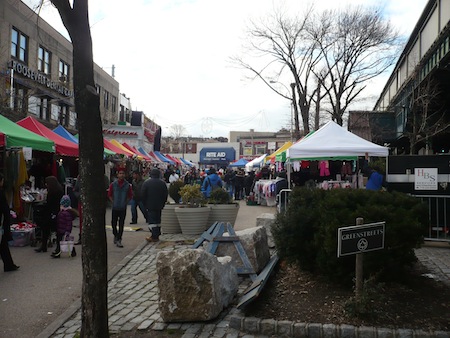
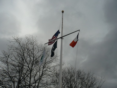
The plaza, a block-long triangle under the El, is part of the Park Department's Greenstreets program and on the day we visited it was hosting a busy marketplace at which, as in the rest of the neighborhood, we heard not a single word of English – Spanish only. Here's the plaza, whatever it's called.

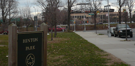
And the naming confusion doesn't stop there. We're only just now getting to our actual destination, 
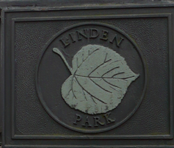
the onetime Linden Park.

For a reason I haven't been able to uncover, Linden Park has been renamed Park of the Americas, though the old sign has much more character than the generic new ones, as usual.

On this blustery December day an airplane cut through the agitated sky.

Was the name change to Park of the Americas related to the famous one that turned Manhattan's Sixth Avenue into Avenue of the Americas? That happened way back in 1945, but it never stuck – no one uses the new name except the post office. Were they trying again with a sneak attack at an obscure little park in Queens? Or could it be because there's a Linden Park in Brooklyn too?

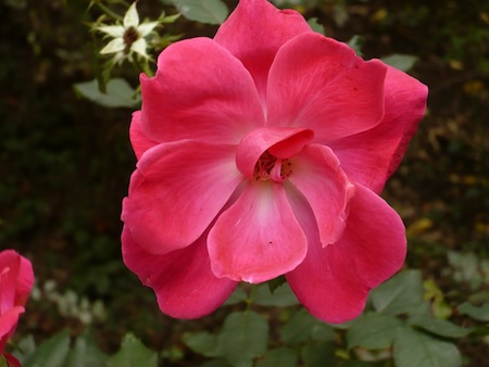
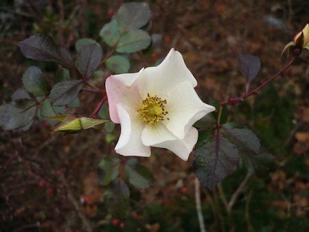
As you can probably imagine, I don't go looking for flower photos in December. But if I happen upon a rosebush that's still putting out, how can I not take advantage, even if I do have to wait a while for a pause between gusts of wind?

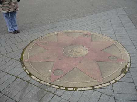
A rose of another sort, this compass rose, points any way you want to go:

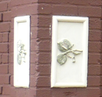
This old detailing on the facilities building continues our horticultural theme while evoking decorative times gone by, when Linden Park was still Linden Park.

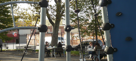
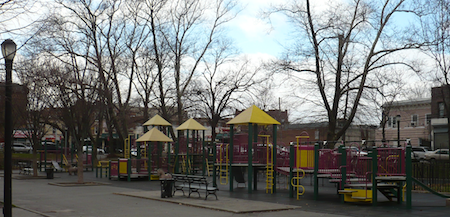
Meanwhile, the playground displays a more modern flair. One good thing about winter is you can sometimes take a picture of a photogenic playground without anyone playing in it.

This one has appealing yellow squiggles and roofs.

Our visit to Linden Park/Park of the Americas was actually occasioned by a trip to the nearby Louis Armstrong House Museum, where Satchmo and his wife lived for decades and which is now operated as a museum – well worth visiting for music fans – by Queens College and a fundraising foundation. It gets a mention on this parks-focused blog because the Armstrongs turned the lot next door into a very nice garden, which now hosts concerts during the warmer months. Despite what I mentioned above, the museum tour is given in English, not Spanish – the only English we heard during our entire excursion to Corona, although the tour guide did mention that the neighborhood has a growing Asian population. In any case, Corona's ethnic makeup has certainly changed any number of times, even just since Lucille Armstrong decided to buy the house on 107th Street back in the early 1940s.

The museum has two paintings of Satchmo by Tony Bennett, who, speaking of name changes, signs his work "Benedetto." But regardless of ethnic changes or name changes of parks and plazas and singers and everything else, I hope we can all agree on one thing: Long live the Louis Armstrong House Museum. And its garden.

Thursday, December 13, 2012

Gorman Park


Now here's something different: a park that's essentially just a giant staircase.

OK, yes, Gorman Park has a terrace-like seating area at the top.

The upper entrance is off Wadsworth Terrace circa 189th St., a block east of and a big climb up from Broadway. Up there is where you'll see the benches, along with a stone wall chiseled with the vital information that the park was named for a real estate investor (how New York is that?) named Gertie Amelia Gorman. But once you get beyond that flat balcony, it's pretty much nothing but big wide stairs, hairpinning all the way down the hill.

Gorman Park volunteers work to beautify the park. Several people were there clipping during my December visit, although the results of their work are surely prettier in the warmer months.

The most recent entry on their website, from June, has this invitation, which must have been irresistible: "I hope you can make it by Gorman Park tomorrow for some exciting weeding and ground-cover planting." Exciting? Really?

But I always like discovering that even the smaller, more obscure parks around the city have devoted neighborhood boosters. It shows how important parks are, every one of them, to urbanites. Long live Gorman Park.

Incidentally, speaking of stairs, my walk from nearby Bennett Park to Gorman Park took me along 187th St. which itself consists, for one block, of a huge bank of stairs (eight flights, I think). They don't call it Washington Heights for nothing.

Wednesday, December 12, 2012

Bennett Park: Highest Point in Manhattan and Site of Fort Washington


Though named for the founder of the New York Herald, a newspaper launched in 1835, 
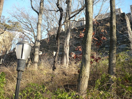
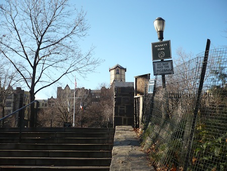
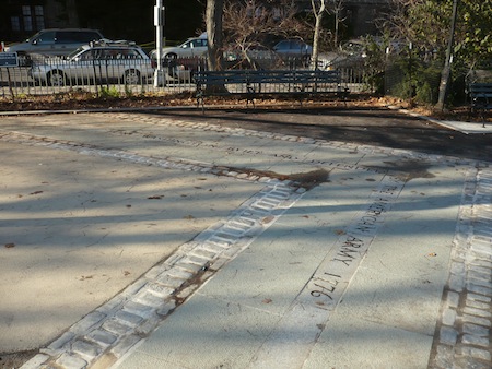
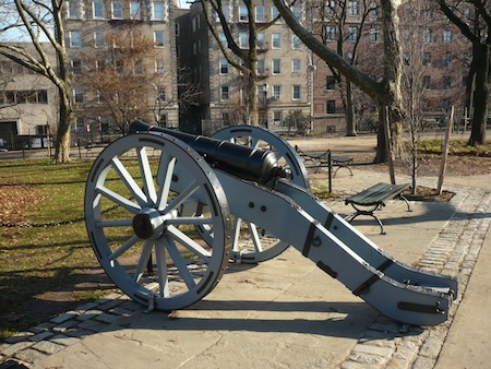
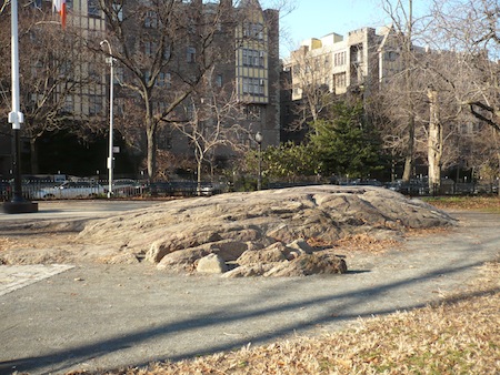
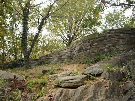
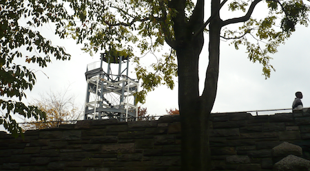
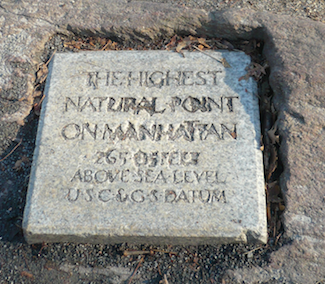
Bennett Park in Washington Heights carries much more history than that. Belying its modest appearance, this small uptown park occupies the highest point on the island of Manhattan and the site of Fort Washington, where General George Washington and his Continental Army made their last stand on Manhattan in 1776 before the British rolled over the city.

I would have figured the island's highest point above sea level would be somewhere along the western edge, with its dramatic views down to the Hudson River, or maybe in an uptown park with a real climb in its midst, like Marcus Garvey Park. But no, it's at this much humbler site a few blocks inland from the river.

Ron Chernow in Washington: A Life describes Fort Washington as "a huge pentagonal earthwork" whose "defenses meandered across a rocky bluff stretching from present-day 181st to 186th streets." But it "had several significant defects" – no internal water source, no topsoil for trench building, not enough room to shelter all the forces, and so on. In the fall of 1776 Washington's men "were shivering with cold, ravenous for food, and prey to one malady after another."

Not only that, the strategy of using Fort Washington, together with Fort Lee across the river in New Jersey, to prevent the British from moving ships up the Hudson failed, and Washington's army didn't last long on this site. Granite paving marks the original contours of the fort. The engraving in the photo below reads "Fort Washington Built and Defended by the American Army 1776."

A replica of a Revolutionary War cannon stands guard:

At the high point of what now feels like a very modest hill, an outcropping of good old Manhattan schist bursts up out of the pavement:

Bennett Park has a nice playground as well, but the park as a whole is in the midst of a multiyear upgrade project. With budget cuts, and in our new era of superstorms, there's no telling when any particular parks project will get finished, but another visit next year or the year after might produce very different photos than these December shots. In the meantime, pay a visit to this historic high point and remember New York City's importance in America's struggle for independence.

Wednesday, November 7, 2012

Albert's Garden and the Trust for Public Land


Studding the city are small gardens like little green jewels. Many are community gardens established on vacant properties, looked after by community groups, and never entirely safe from development.

Albert's Garden looks just like such a space, but isn't. The property on 2nd St. by the New York Marble Cemetery in Manhattan's East Village was secured back in 1999 by the Trust for Public Land, an organization devoted to the noble cause of "conserving land for people." If there's a higher calling than that, I'm hard pressed to think of it.

It was in the course of a failed attempt to visit the Marble Cemetery that we discovered Albert's Garden. A listing in Time Out New York said there'd be a rare opportunity to visit the cemetery that day, but alas, the boneyard proved to be locked up tight and silent. But then Albert's Garden appeared. Owned by the Manhattan Land Trust, which has over a dozen such properties around the island (including Parque de Tranquilidad), Albert's is a lush, nicely cared for garden. That's all there is to it, and all there has to be.

Friday, November 2, 2012

Marcus Garvey Park


At an impressively hilly 20 acres, the former Mount Morris Park has been a city park since 1840. It was renamed Marcus Garvey Park in 1973 after the prominent Black Nationalist, who hailed from Jamaica and was educated in London but worked out of Harlem in the early part of the 20th century with the organization he had founded, the Universal Negro Improvement Association.

From the southern entrance at Fifth Avenue and 120th St. the park has a somewhat forbidding look, with a wall of schist overlooked by a second, man-made wall.

This impression gives way to an imposing but relatively welcoming set of stairs leading to the park's central Upper Level. The British used this high point as a lookout site during the Revolutionary War. Today's it's topped by a historic cast iron fire tower built in 1856. (Back then practically the whole city was made of wood, so it paid to keep a vigilant lookout for fires.)
On a temperate Saturday in the fall, not many people were using the Upper Level paths. It was possible to feel isolated amid the landscape's grand sweep.
By contrast, a whimsical fence runs alongside the large outdoor swimming pool.
Looking up the Mount, a landscape of rocks, trees, and autumn leaves led up to the wall.
On the west side of the park a lone spectator took in an imaginary show at the Richard Rodgers Amphitheatre.
Fall isn't the best time for flower photos, but I took advantage of a rare opportunity here.
On the east side there's a drummers' circle along with play areas and walkways. While walking the park's perimeter I also encountered this striking juxtaposition of the natural and the man-made:
But the most remarkable thing I encountered on my mini-trek through this fine park had to be the amazing burl on this plane tree.
And with that, we leave Marcus Garvey Park for now, noting that Superstorm Sandy, in whose aftermath I write this, may have damaged any number of the trees and other elements I've documented on this blog in this park and many others. All the city parks have been closed all week; when they reopen I'll get a look at some of the damage done. Meanwhile, be glad, as I am, that New York City has so many and such a great variety of excellent parks. May they weather every storm.

Sunday, October 28, 2012

Gilbert Ramirez Park


This one-acre park in Bushwick, formerly known as McKibben Park, opened in 1936 and was renovated around the turn of the 21st century with a play area that has a subway theme, including a play subway entrance and fanciful metal wall panels.
Justice Gilbert Ramirez Park was named for the first Puerto Rican elected to the New York State Assembly, in 1965. Ramirez later became a Justice of the State Supreme Court and a noted community leader. His park today has places for "passive enjoyment" – picnic tables, benches – which are what make it more than just a playground.

Across McKibben St. is a construction wall with some eye-catching graffiti and a view of tall white tanks behind it, about whose identity some knowledgeable Brooklynite will have to enlighten me. A view through the swings struck me as picturesque. (What can I say? I'm a writer, not an artist like those whose exhibits at the nearby Bushwick Open Studios occasioned this trip to the culturally hopping neighborhood.)

A final note: One corner of the park is devoted to a tiny community garden with an admirable philosophy. I write this as we batten down for the arrival of Hurricane Sandy, which will surely down a lot of trees around the city. Let's give a moment's thought to the trees that make the city livable, and to the apprehension of the evil creatures who "girdled" (effectively killing) 15 trees in Pelham Bay Park earlier this month.

Monday, August 13, 2012

Jacob Riis Park

Not a city park, but a part of the Gateway National Recreation Area, Jacob Riis Park honors the great Danish-American photographer and journalist who documented life on the poor side of town in the New York of an earlier age. The beach at Jacob Riis Park was, appropriately perhaps, intended as a getaway to which car-less city folk could actually get away, as opposed to, say, Jones Beach. Today, public transportation here from most parts of the city involves a long trip via subway and bus – or a ferry which leaves, ironically, from Wall Street.

If you drive, there's plenty of parking in the enormous sunbaked lot.

There's pitch-and-putt golf, but Jacob Riis is mostly a beach, and there's nothing wrong with that. On the day of our visit this summer the water was extremely rough – no chance for swimming, but you could get wet and salty and have fun.


That's right. It's a beach.

Like Jones Beach, and with similar architecture (on display at the Riis Bathhouse, below), Jacob Riis Park was laid out by megalomaniacal city planner Robert Moses in the 1930s on the site of an early U.S. naval air station. It became part of the National Park system in 1972.

In its present condition, this clock won't actually help you tell the time. But it will remind you of times gone by.

Sunday, July 22, 2012

Pelham Bay Park


In area, Pelham Bay Park in the Bronx is New York City's largest park, but in public consciousness it's much smaller. A big part of the reason is the paucity of public transportation. The park contains golf courses, Orchard Beach, and a historic mansion and grounds, but getting there without a car takes real planning.

The Bartow-Pell Mansion from the edge of the rear woods

Not having done any planning (except to check the Barlow-Pell Mansion website for its hours), we got in the car and crawled our way through construction traffic to the wet green corner of the Bronx called Pelham Bay Park, aiming first for the mansion. It's the only one remaining of the many large estate houses that used to dot this area; when the city acquired the land in the late 19th century, they all ended up going the way of the dinosaurs except this one, which, built around 1840, later became the headquarters of the International Garden Club, which added the formal gardens around the time of World War I.
The mansion has been a museum since 1946, and it's been populated with period furnishings.
There's some modest landscaping in the vicinity…
…and a few trees that have a lot of personality…
But things get wild pretty fast as you wander out back of the mansion grounds. A yellow-marked but partly overgrown trail (look out for poison ivy, and check for ticks when you're done) takes you along the shore of the Lagoon. On the other side of this water is a landfill on the far side of which sits Orchard Beach, but at this lower section, there's no civilization in sight.

With your back to the Lagoon you can look out over this lush sward.
You can ride a horse in Pelham Bay Park, or bike on the bike paths. But the whole place has a very un-manicured quality; this park is huge, but it's about as different from Central or Prospect Park as you can get and still be a park. Of course, anytime there's a beautiful weekend day, people are going to take advantage. In this parking area by the ballfields (ballfields completely unused during our visit), people had gathered to, uh, sit in the parking lot and eat and socialize. One interesting sight and sound: men playing live percussion along with a recording of Latin music.
Golf, beach, horses, a historic house, beautiful watery views – Pelham Bay Park has a lot. But it's not too conducive to just wandering about. Robert Moses, not Frederick Law Olmsted, shaped much of this area. In the mansion's little museum room, there's a photo of Fiorello LaGuardia using the Bartow-Pell mansion as a "City Hall in the Country" and a placard explaining that one reason the Mayor spent time here was to "keep an eye on" Moses's vast geographic manipulations.